![Sabanto-Horizontal-Orange-on-Transparent-RGB-1080px-05.16.23.png]](https://support.sabantoag.com/hs-fs/hubfs/Sabanto-Horizontal-Orange-on-Transparent-RGB-1080px-05.16.23.png?height=50&name=Sabanto-Horizontal-Orange-on-Transparent-RGB-1080px-05.16.23.png)
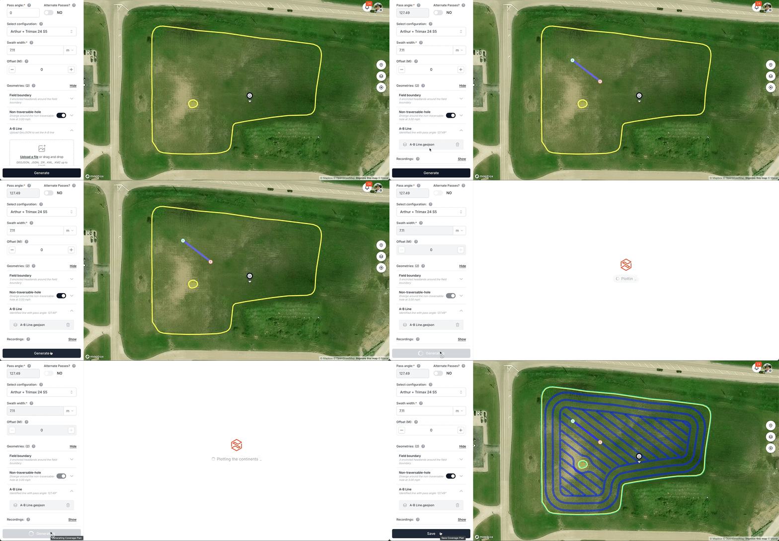
An A-B line is a straight reference line that defines the direction and alignment of passes in a coverage plan. When uploaded, it overrides the manual pass angle input and ensures that one generated pass aligns exactly on the A-B line, with all other passes spaced at swath-width intervals.
How to use it
- Open the Coverage Planner for a field with at least one geometry loaded.
- Expand the A-B Line accordion (below the geometry list).
- Upload a file by dragging into the dropzone or clicking Upload a file.
- The pass angle is automatically calculated from the line's bearing and the angle input is locked.
- Generate the plan — the backend aligns passes to the uploaded line.
To remove the A-B line, click the trash icon. The pass angle reverts to its previous value.
Accepted file formats
Maximum file size: 50 MB.
| Format | Extension |
|---|---|
| GeoJSON | .geojson |
| JSON | .json |
| Shapefile (zipped) | .zip |
| KML | .kml |
| KMZ | .kmz |
Validation rules
The uploaded file must contain:
- A LineString geometry with at least 2 coordinates.
- An open line (not a closed ring). If the first and last coordinates are identical, the upload is rejected with: "This file appears to contain a closed loop, not an A-B line."
How the pass angle is calculated
- The first and last coordinates of the LineString are extracted.
- A rhumb bearing is computed between those two points.
- The bearing is normalized to 0–180° (pass direction is symmetric — north-to-south and south-to-north are equivalent).
How pass alignment works
When an A-B line is provided, the system calculates an offset so that one generated pass falls exactly on the A-B line. All other passes are spaced at uniform swath-width intervals from that position, ensuring consistent alignment across the field.
Interaction with other settings- Pass angle input: Locked while an A-B line is active.
- Headlands: The A-B line accordion remains accessible regardless of headland selection.
- Map visualization: The A-B line renders as a colored line with a green A marker and red B marker at the endpoints.
Troubleshooting
"File must contain a LineString with at least 2 coordinates"
The file contains a Point, Polygon, or empty geometry. Re-export the line as a LineString with 2+ vertices.
"This file appears to contain a closed loop"
The first and last coordinates are identical (e.g. a field boundary was uploaded instead of a line). Upload a straight reference line, not a polygon.
"Could not parse the uploaded file"
The file is corrupt or has an unsupported internal structure. Verify it opens correctly in QGIS or geojson.io, then retry.
Pass angle input is greyed out
An A-B line is currently active. Clear the A-B line (trash icon) to manually edit the angle.